SENGGIGI BEACH LOMBOK


Senggigi is Lombok's oldest and most famous resort area.

A perfect place to relax, Senggigi boasts a series of white sandy beaches and safe swimming areas. The point at central Senggigi has good waves for surfers. This place has a colourful reef which provides shelter to a variety of marine life and exquisitely shapped coral and makes it a perfect place to snorkle.

In the dry season, there is an interesting variety of boats moored in the bay. The town of Senggigi spreads out along nearly 10 kilometers of coastal road. This road continues north to Bangsal, the port for the Gili Islands. 

PULAU MERAH BEACH

Banyuwangi, located at the most-eastern edge of Java can boast yet another world class surf spot next to the already well known G-land at Plengkung: this is Pulau Merah Beach. 


Pulau Merah Beach is so called since just some 100 meters to the side of the beach is a picturesque little hilly island called Pulau Merah, that is reachable on foot. This is situation is similar to the location of the island of Tanah Lot to the main island of Bali.   But unlike at G-land where are found sharp coral rocks by the beach, the beach at Pulau Merah – or the Red Island Beach – is open sand so that it is also safe for beginner surfers.   


Compared to Bali’s Kuta Beach, surf here is stronger, offering large four meters high barrels with a length of 400 meters, ideal for surfers to try out tubing techniques. But since surf here comes in at an average of two meters height, beginners and amateur surfers alike can enjoy this beach. Whereas,  the beaches at Plengkung and G-land should be ventured by professionals only. 


Pulau Merah beach was originally known as Ringin Pitu. There are two versions for its name change. One version has it that because the color of the soil and sand are reddish, this is where it got its name from, while another story says that at one time some bright red rays shone from the small hilly Pulau Merah island onto the beach, thus giving it the name Pulau Merah beach. 


Another feature of the beach is the nearby fishing village called Pancer, where you can stay at villagers’ homes. Their hospitality to visitors in spite of their simple life is truly heartwarming.

Bangka - Belitung Islands.

Bangka-Belitung is one of Indonesia provinces. It includes two large islands, Bangka and Belitung, and several smaller ones, which lie east of Sumatra, northeast of South Sumatra province. Bangka Belitung (BABEL) Islands province is the 31st Province in Indonesia, one of the newest provinces. Bangka Belitung get it’s approved as a new province in 2001 separated with south Sumatra. That acknowledgement is because of the people struggle. The region that was a great tin mines, now already to reach the new phase in its life. It provisioned with the beautiful of nature, and the uniquely of culture, Bangka Belitung step to the better future.

Supported by the “Serumpun Sabalai” spirit and abundant natural resources, it has been expecting a greater role to speed up the island region's development, namely Bangka regency, Belitung regency and Pangkal Pinang city through cooperation development. That potency of culture and tourism is also supported by its strategic location that can connect with other interesting area. The sea transportation that become the most accessibility in Bangka Belitung Island, is support its economics activities among the Islands.

The richness of Bangka Belitung Island of nature and tin mines until its maritime rich, make Bangka Belitung a magnet for the new comers to get a better life. A Balinese countryside is found in this Island named Giri Jati village, complete with all of Bali culture that remembering us to Bali Island. Beside Bali tribe, we also can found Bugis tribe that adds the various cultures in Bangka Balitung Island. This Bugis tribe can be found in the fishermen village at Tanjung Binga. Otherwise, the original tribe, Melayu culture has strong influence in the traditional ceremony and religious ceremony. One of the ceremonies is Rebo Kasan Ceremony that done by Air Anyer village people. It is believed that one day of a year, the God give His 320,000 angels in the world. The people must together to pray. This ceremony was held in the beach, but now on, it held in the mosque then continued to the beach. Formerly, this ceremony become the people party with its star party is ‘Dambus’ art.

Geographically

Bangka Belitung province is located between 104°50' - 109°30' East Longitude and 0°50' - 4°10' South Latitude, with its total area of 81,724.54 km.

Administrativelly

Administrativelly, Bangka Belitung comprises of 2 regencies and 1 city, namely Bangka regency, Belitung regency and Pangkal Pinang City, of which, the biggest regency's area is Bangka regency with 11,534.14 km area, and the smallest is Pangkal Pinang City, with 89.40 km area.

Climate

There are two seasons that are suitable for sailing to these islands: February-March and October-November, when the wind and the waves are low. The heaviest rainfall is around 2,500 mm per annum with its average temperature between 25°C - 26°C.

Population

In 2001, Babel's population was 920,729 consisted of 462,640 men and 458,089 women. The biggest population among the regencies was Bangka regency, 583,841 people, while the most density population was Pangkalpinang City, with its 1,396 people/km. In 2001, the growth of population reached 1.49 % per annum averagely. Labor. In 2000, its labor force recorded as many as 100,825 people.

Bunaken Island, North Sulawesi


Bunaken is an island of 8 km², part of the Bunaken National Marine Park. Bunaken is located at the northern tip of the island of Sulawesi, Indonesia. It belongs administratively to the municipality of Manado. Scuba diving attracts many visitors to the island.


Other sides of Bunaken.
Bunaken National Park extends over an area of 890.65 km² of which only 3% is terrestrial, including Bunaken Island, as well as the islands of Manado Tua, Mantehage, Nain and Siladen.

The waters of Bunaken National Marine Park are up to 1,566 m deep in Manado Bay, with temperatures ranging between 27 to 29 °C. It has a high diversity of - corals, fish, echinoderms or sponges. Notably, 7 of the 8 species of giant clams that occur in the world, occur in Bunaken. It also claims to have seven times more genera of coral than Hawaii, and has more than 70% of all the known fish species of the Indo-Western Pacific.

Oceanic currents may explain, in part, why Bunaken National Marine Park has such a high level of biodiversity. Northeasternly currents generally sweep through the park but abundant counter currents and gyros related to lunar cycles are believed to be a trap for free swimming larvae. This is particularly true on the south side of the crescent-shaped Bunaken Island, lying in the heart of the park. A snorkeler or diver in the vicinity of Lekuan or Fukui may spot over 33 species of butterfly fish and numerous types of groupers, damsels, wrasses and gobies. The gobies, smallish fish with bulging eyes and modified fins that allow them to attach to hard surfaces, are the most diverse but least known group of fish in the park.

Tiger Island Jakarta


Welcome to Tiger Islands Village & Eco Resort. Life is simple and good here :~) The  two gorgeous islands upon which we have built this paradise exemplify the best of tropical living while introducing modern eco technologies and comforts. The natural environment is stunning and features white sandy beaches, aquamarine waters, colorful corals, playful fish, and lush tropical vegetation. Our food, some of it grown within our organic gardens, is fresh and delicious. Our cabins and structures are simple and comfortable. We’ve got books and DVDs in our media library, and plenty of watersports equipment and island toys. The folks that look after you are from an extended family that have lived on the island for more than 15 years. These friendly, humorous, and innovative staff are your chefs, your housekeepers, your boat captains, your bonfire-builders, your guides, and your friends. Whether you are staying for a weekend or an extended visit, we are always pleased to welcome guests to this tropical paradise. Our vision is to make you feel at home within our beautiful environment, and introduce you to some of the solutions we’ve applied to make our little world a better place. Sustainable energy, environmental stewardship, organic gardening, intelligent waste management, community development, and evolved learning are all part of our life here. When you discover what an amazing vibe results from the combination of these elements, you’ll see why many have called our two little islands paradise :~) Our home is situated within the largest archipelago in the world, off the North West coast of Java, Indonesia, just 88 minutes from Jakarta.

Baluran National Park Situbondo

Baluran National Park is located in Situbondo Regency, East Java, Indonesia. It has a relatively dry climate and mainly consists of savanna (40%), as well as lowland forests, mangrove forests and hills, with Mount Baluran (1,247m) as its highest peak.

Baluran National Park is situated at the north-eastern extremity of Java, close to the islands of Bali and Madura. The park is bordered by the Madura Strait to the north, the Bali Strait to the east, the river Bajulmati (Wonorejo village) to the west and the river Klokoran (Sumberanyar village) to the south. The park is a rough circle, with the extinct volcano, Baluran, at its centre. Its total area is 25,000 ha. It consists of five zones: the Main Zone (12,000 ha), the Wilderness Zone (5,537 ha, comprising 1,063 ha water and 4,574 ha land), the Intensive Utilization Zone (800 ha), the Specific Utilization Zone (5,780 ha) and the Rehabilitation Zone (783 ha).

Flora and fauna

Ziziphus mauritiana trees in the park
There have been 444 species of plant recorded in the park, including some endangered plant species, such as: Ziziphus rotundifolia, Tamarindus indica, Dioscorea hispida, Aleurites moluccanus and Corypha utan.

The park is host to 26 species of mammals, including the endangered banteng, dhole, Indian muntjac, Java mouse-deer, fishing cat, leopard and Javan lutung. The banteng population decreased form 338 in 1996 to just 26 in 2012.

Bird species in the park include the green peafowl, red junglefowl, Malabar pied hornbill, rhinoceros hornbill and lesser adjutant. Until 2010 there had been 155 species of bird recorded in the park, but following a bird photography competition in 2012, the number of species was revised to 196.

Conservation and threat
The area has been protected since 1928, first initiated by the Dutch hunter A.H. Loedeboer. In 1937 it was declared a wildlife refuge by the Dutch colonial government. In 1980 the are has been declared a national park.

Poaching poses a major threat to the wildlife in the park, especially to the decreasing Banteng population. According to ProFauna Indonesia, not only locals but also members of the military have been involved in poaching.[6]

Acacia nilotica has occupied at least 6,000 hectare of the savannah at Baluran National Park made Bos javanicus (banteng) had difficulty to find their foods. In 2013, there are only 35 banteng, while in 1996 there are still 320 banteng.

Karimunjawa Islands Jepara

Karimunjawa is and island chain stretching in a northwesterly direction 83 km from Jepara. Central Java. This archipelago is a cluster of 27 islands in the java sea. Only seven of the islands are inhabited. The reefs are a mixture of fringing, barrier, and patch with bottom depths ranging from 15 to 40 meters. The name of Karimunjawa is taken from Javanese language 'Kremun kremun saking tanah Jawi' addressed by one of Wali Songo (the Nine Saints who had introduced Islam in Java) to describe how far this mini archipelago from Java, to be exact from Semarang and Jepara. Stands from 27 islands, this mini archipelago became marine national park and it's like a treasure for those who love marine life. Here can be found protected coral reefs (very colorful plateaus and plains in deep and shallow waters), secluded and tranquil white beaches, pelican and hornbill, sea grass and kinds of sea creatures, from crabs, anchovy, starfish, sharks, stingray, jellyfish, red snappers, etc.

The Marine National Park Karimun Jawa is 110,000 ha and lies 90 km north east of Jepara in Central Java. We will find mangrove forest and beach forest. The park is named after the largest island Karimun Jawa. The vegetation consists mainly of mangrove and beach forest, although there is some lowland rain forest on Karimun Jawa. Most of the islands are surrounded by sandy beaches and fringing coral reefs. Fresh water is confined to a few small wells and forest streams on Karimun Jawa. A number of endemic animals live on the island while on the beaches sea turtles lay their eggs. The average tidal range is 92 cm.

The archipelagic Karimunjawa, thought not as known the Marine reserves near Ambon and Manado, has unexpectedly good beaches, reefs and lovely sea scopes. Corals seem to blossom in to gardens, with an Amazing variety of form and color fishers and marine plants. It lies 90 km away from Jepara and can reached by "KM. Adison I & KM Kota Ukir" boat, the only ferryboat connecting Karimunjawa and Jepara. The resort offers stunning dives and snorkeling trips for all sorts of divers from novice to experience. Fringing reefs, atolls, wrecks and an excellent variety of different species make diving in Karimunjawa an unforgettable adventure.

Tanjung Papuma Beach Sunrise, Jember

Tanjung Papuma Beach Sunrise, Jember
Tanjung Papuma Beach Sunrise, JemberTanjung Papuma Beach is an amazing beach with the sunrise view on the highest top, it located in southern coastal of jember regency, East Java Island Indonesia. This beach is called as “PAPUMA BEACH” the abbreviation of Pasir Putih Malikan (white sand of Malikan). Papuma known as a rocky beach because of high rocks that surround the spot make this beach very spectaculer, many sailing boats along the seashore parking with various colourful design and type. Papuma beach is very suitable to enjoy sunrise, just trek up for 10 minutes through the stairs from the parking area to the high paek, started at 05:00 AM, After you get the top of Papuma, you will see the sunrise and a wide of southern sea that decorated by many high rocks and great terrifying waves it is really awesome from the highest peak of Papuma.

The beauty of Tanjung Papuma Beach Sunrise, Jember

Tanjung Papuma Beach, JemberThe beautiful white sand is pleasure to see and to walk on. The beach is always used as the place for sunbathing by foreign tourists. Besides its natural scenic beauty, it is also rich of animals, such as the lizard, forest cock, various birds, wild pig, deer porcupine, scaly anteater and many others. The scenery and atmosphere can be enjoyed more completely at a restaurant which provides Indonesian and typical food of Papuma, Jember.

In this beach provided some reservation and supporting tools for visitors that want to enjoy Papuma circumstance like some lodges and camping ground. When the sunset time almost arrives, the atmosphere of Papuma will seem more beautiful tobe enjoyed. Especially when the time approaching to the dusk that interspersed with hard wind cause the circumstance into dramatic ambience. The situation at night always felt little bit noisy because of the waves striking around the rocky area always come alternately.

The way to reach Tanjung Papuma Beach of Jember

Tanjung Papuma Beach is possible reached from Banyuwangi, Surabaya and Malang City. If you start from Surabaya Airport or Malang City, the trip is 8 hours driving and 3 hours from Banyuwangi Ketapang Harbor. it possible by motor bike or car. Most visitors enjoy Tanjung Papuma Beach after or before enjoy Ijen Crater because the trip only 3 hours driving.

Before you visit Tanjung Papuma Beach, Jember. You can ask detail tour package price, facilities and some required reservation to Our partners by contact form have available. We are the tour organizer, serve the domestic and foreigner costumers to explore the beauty of Tanjung Papuma Beach Sunrise, Jember and other tourism objects in East Java Island Indonesia with complete service and various tour package price, depend on your planning and necessaries.

Alor Island

Alor (Indonesian: Pulau Alor) is the largest island in the Alor Archipelago located at the eastern Lesser Sunda Islands that runs through southeastern Indonesia, which from the west include such islands as Bali, Lombok, Sumbawa, Komodo, and Flores.

To the east of the island across the Ombai Strait lie the islands of Wetar and Atauro, the latter belonging to East Timor. To the south, across the Strait of Alor, lies the western part of Timor. To the north lies the Banda Sea. To the west lies Pantar and the other islands of the Alor archipelago, and further yet the rest of the Sunda Islands.

Alor is one of the 92 officially listed outlying islands of Indonesia.

On 12 November 2004, an earthquake measuring 6.0 on the Richter scale occurred, killing 34 people.

Alor has an area of about 2800 km², making it the largest island of the Alor archipelago.

Kalabahi is the only town on the island of Alor, with a metropolitan population of about 60,000. The variety of goods obtainable in Kalabahi is surprising considering its size and location. The 2010 census population of the island is 145,299 out of 190,000 in the regency.[1]

Alor is of volcanic origin and has very rugged terrain. The region near Kalabahi is the only flat area. This is why the Dutch placed the capital and the main harbor (Alor-Kecil) of the area here in 1911.

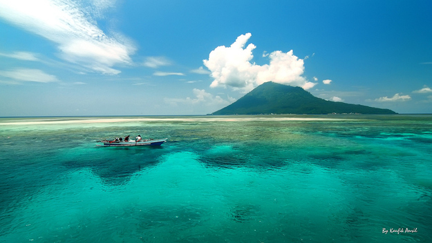
"The best" snorkelling and diving in Indonesia can be found in the Alor archipelago. Due to intriguing and often very strong currents it is best to snorkel or dive with someone who knows the area well. Transportation to Alor by TransNusa Trigana Air, from Kupang, Denpasar and Surabaya.

The island's infrastructure is only weakly built. The inhabitants practice mainly subsistence agriculture. The government seeks to change this with the help of international organizations. In the villages, vanilla, tamarind, almonds and other nuts are cultivated. In the forests sandalwood is cut down for trade.

The latest geological explorations have discovered valuable resources such as gypsum, kaolin, petroleum, natural gas, tin, gold, and diamonds.

Alor's highly esteemed snorkeling and diving promise an increase in tourism in the future. Depletion of the fisheries has however damaged the coral reefs in recent years.

More than 15 different indigenous languages are spoken on Alor, the majority of them classified as Papuan or non-Austronesian. These include Abui, Adang, Hamap, Kabola, Kafoa, Woisika, Kelon, and Kui. In addition, Alorese (Bahasa Alor; ISO 639-3: aol) is a Malayo-Polynesian language which is spoken along the coast of the western and southern Bird's Head of Alor Island and in places on surrounding islands.

Many of the Papuan languages of Alor are endangered and are no longer being actively acquired by children. Some languages have fewer than 1000 speakers remaining. Significant linguistic documentation efforts have been undertaken recently by Leiden University.

The language of daily communication is Alor Malay, a unique Malay variety with some similarities to Kupang Malay. Indonesian is taught in schools and used widely in media.

Transportation[edit]
During the dry season, Kalabahi is serviced by flights five times a week from Kupang the provincial capital, using a [ATR42] 46 seat by TransNusa Trigana Air and Kasa[disambiguation needed] 18-seat airplane. These flights are run by Merpati Airlines. Most of them are simply Kupang–Kalabahi–Kupang, but mid-2003 a new flight Kupang–Kalabahi–Kisar–Ambon, returning the next day, was introduced. The two Pelni passenger ships Serimau and Awu also pass through Kalabahi each week. Transport to Alor during the wet season is sometimes disrupted due to high winds and large waves.

On 17 November 2006 Trigana Air suffered its first ever plane crash accident. The aircraft (a de Havilland Canada DHC-6 Twin Otter 300) struck a mountain in Puncak Jaya (Indonesia) seven minutes before it was scheduled to land in the remote Indonesian province of Papua. All 12 passengers on board died shortly after the incident.

Alor island has its own airport.

Lake Toba

Lake Toba (Indonesian: Danau Toba) is a large natural lake occupying the caldera of a supervolcano. The lake is about 100 kilometres long, 30 kilometres wide, and up to 505 metres (1,666 ft) deep. Located in the middle of the northern part of the Indonesian island of Sumatra, with a surface elevation of about 900 metres (2,953 ft), the lake stretches from 2.88°N 98.52°E to 2.35°N 99.1°E. It is the largest lake in Indonesia and also the largest volcanic lake in the world.

Lake Toba is the site of a massive supervolcanic eruption estimated at VEI 8 that occurred 69,000 to 77,000 years ago, representing a climate-changing event. It is the largest known explosive eruption on Earth in the last 25 million years. According to the Toba catastrophe theory, it had global consequences for human populations: it killed most humans living at that time and is believed to have created a population bottleneck in central east Africa and India, which affects the genetic make up of the human world-wide population to the present.

It has been accepted that the eruption of Toba led to a volcanic winter with a worldwide decrease in temperature between 3 to 5 °C (5.4 to 9.0 °F), and up to 15 °C (27 °F) in higher latitudes. Additional studies in Lake Malawi in East Africa show significant amounts of ash being deposited from the Toba eruptions, even at that great distance, but little indication of a significant climatic effect in East Africa.

BALI PANDAWA BEACH

BALI PANDAWA BEACH IS KNOWN AS A SECRET BEACH DUE LOCATION OF THE BEACH IS DIFFICULT TO ACCSESS

Bali Pandawa Beach is located in Kutuh Village, South Kuta District, Badung Regency; around 3 km from the famous Nusa Dua area and Uluwatu Temple. In the past, this beach was hidden behind hill so it was called Secret Beach. Secret Beach actually had known well by some tourists. However, the difficult access to this location made this beach was empty. The visitors of this beach were only a few foreign surfers or domestic tourists. Fortunately, the local government of Badung Regency realized the potential of this beach and quickly managed this beach then launched it as a new mainstay attraction. The result can now be felt such as a better access heading to the beach which is now become more convenient for any vehicles. Pandawa Beach has a stunning panorama with serene and quiet atmosphere. When entering the beach area, we will be amazed by beautiful panorama of high cliff, flanking the road along 1.5 km. The road is purposively built through limestone hills in Kutuh Village, similar with the hills in GWK.

Pandawa Beach is The Bali Secret Beach
Formerly, Pandawa Beach is a hidden and secret beach that was very difficult to access due to located in the deep valley and surrounded by the white stone cliff. We must go through a small step down on the cliff with dangerous valley underneath and the only local people can access the beach since they were own daily job as fishermen and seaweed farmer. But today, the old story was changed. Since local people have the great inspiration to build their village, they work together to break the cliff and make the good road and can be accessed by any vehicles. Since the access is created, many visitors from foreign country either domestic visit this beach every day.

Statue Panca Pandawa at Pandawa Beach
When we pass through the new access to Pandawa Beach, we will be provided a complimentary amazing view of white sandy beach with Indian Ocean just in front of it. On the way down to the beach, we will discover several caves with beautiful ornament of white stone statue taking the inspiration of Panca Pandawa (5 big brothers from Mahabaratha epoch). The statues are beautiful craved with Balinese ornaments and to be one of spot for photo taking when visiting this sight.  The Pandawa Beach's name is taken from the name of 5 big brothers at Mahabaratha epoch consisted of Yudistira, Bima, Arjuna, Sahadewa and Nakula. This story had inspired the Balinese Hindu social life those are reflecting their cultures. There are many places, buildings, people's name, street's name and plenty firm of items in particular statues, puppets and much more taking from this story and Pandawa Beach is one of them.

Story Name Of Pandawa Beach Was Taken
The Pandawa Beach name is taken from the name of 5 big brothers at Mahabaratha epochconsisted of Yudistira, Bima, Arjuna, Sahadewa and Nakula. This story had inspired the Balinese Hindu social life those are reflecting their cultures. There are many places, buildings, people's name, street's name and plenty firm of items in particular statues, puppets and much more taking from this story and Pandawa Beach is one of them.

When entering the area of Pandawa Beach, you will be made astonished by beautiful view in front of you. The sand in this beach is so white and clean which is combined with a background of turquoise sea. The ambience is still quiet, serene, and clean. There are no garbages, and if there is any, those are only the remains of seaweed brought by the wave. This beach is very suitable for swimming because the wave and current is not so strong. Various activities can be done in this beach for example playing sand or sunbathing. Because of its geographical location in the east of Bali Island, we can see the amazing sunrise panorama in this beach.

Besides that, there is also an interesting recreation activity around this area which is called paragliding. If the weather is fine and the wind is quite strong, you can see or try this activity directly. The location for starting this activity is actually not in Pandawa Beach, but in Timbis Hill which is not too far from this beach. Usually, this paragliding activity is done in day or afternoon time, if the weather meets the requirements. While you are paragliding, you will be able to see the true beauty of Pandawa Beach from the height. Don’t worry if you are a newbie or even a first-timer, because a training centre and instructors are available if needed. If you are interested in trying paragliding, you can go to Timbis Hill which is only a few kilometers away from Pandawa Beach.

Komodo National Park


Komodo National Park is located in the center of the Indonesian archipelago, between the islands of Sumbawa and Flores. Established in 1980, initially the main purpose of the Park was to conserve the unique Komodo dragon (Varanus komodoensis) and its habitat. However, over the years, the goals for the Park have expanded to protecting its entire biodiversity, both terrestrial and marine. In 1986, the Park was declared a World Heritage Site and a Man and Biosphere Reserve by UNESCO, both indications of the Park's biological importance.


Komodo National Park includes three major islands: Komodo, Rinca and Padar, as well as numerous smaller islands creating a total surface area (marine and land) of 1817km (proposed extensions would bring the total surface area up to 2,321km2). As well as being home to the Komodo dragon, the Park provides refuge for many other  notable terrestrial species such as the orange-footed scrub fowl, an endemic rat, and the Timor deer. Moreover, the Park includes one of the richest marine environments including coral reefs, mangroves, seagrass beds, seamounts, and semi-enclosed bays. These habitats harbor more than 1,000 species of fish, some 260 species of reef-building coral, and 70 species of sponges. Dugong, sharks, manta rays, at least 14 species of whales, dolphins, and sea turtles also make Komodo National Park their home.

 
Threats to terrestrial biodiversity include the increasing pressure on forest cover and water resources as the local human population has increased 800% over the past 60 years. In addition, the Timor deer population, the preferred prey source for the endangered Komodo dragon, is still being poached. Destructive fishing practices such as dynamite-, cyanide, and compressor fishing severely threaten the Park's marine resources by destroying both the habitat (coral reefs) and the resource itself (fish and invertebrate stocks). The present situation in the Park is characterized by reduced but continuing destructive fishing practices primarily by immigrant fishers, and high pressure on demersal stocks like lobsters, shellfish, groupers and napoleon wrasse. Pollution inputs, ranging from raw sewage to chemicals, are increasing and may pose a major threat in the future.

Today, the PKA Balai Taman Nasional Komodo and PT. Putri Naga Komodo are working together to protect the Park's vast resources. Our goals are to protect the Park's biodiversity (both marine and terrestrial) and the breeding stocks of commercial fishes for replenishment of surrounding fishing grounds. The main challenge is to reduce both threats to the resources and conflicts between incompatible activities. Both parties have a long term commitment to protecting the marine biodiversity of Komodo National Park. 

Mount Rinjani


Mount Rinjani or Gunung Rinjani is an active volcano in Indonesia on the island of Lombok. Administratively the mountain is in the Regency of North Lombok, West Nusa Tenggara (Indonesian: Nusa Tenggara Barat, NTB). It rises to 3,726 metres (12,224 ft), making it the second highest volcano in Indonesia.

On the top of the volcano is a 6-by-8.5-kilometre (3.7 by 5.3 mi) caldera, which is filled partially by the crater lake known as Segara Anak or Anak Laut (Child of the Sea) due to blue color of water lake as Laut (Sea). This lake is approximately 2,000 metres (6,600 ft) above sea level and estimated to be about 200 metres (660 ft) deep; the caldera also contains hot springs. Sasak tribe and Hindu people assume the lake and the mount are sacred and some religion activities are occasionally done in the two areas.

A massive eruption of Rinjani in 1257 CE may have triggered an episode of global cooling and failed harvests.

Lombok is one of the Lesser Sunda Islands, a small archipelago which, from west to east, consists of Bali, Lombok, Sumbawa, Flores, Sumba and the Timor islands; all are located at the edge of the Australian continental shelf. Volcanoes in the area are formed due to the action of oceanic crusts and the movement of the shelf itself. Rinjani is one of at least 129 active volcanoes in Indonesia, four of which belong to the volcanoes of the Sunda Arc trench system forming part of the Pacific Ring of Fire – a section of fault lines stretching from the Western Hemisphere through Japan and South East Asia. The islands of Lombok and Sumbawa lie in the central portion of the Sunda Arc. The Sunda Arc is home to some of the world's most dangerous and explosive volcanoes. The eruption of nearby Mount Tambora on Sumbawa is known for the most violent eruption in recorded history on 15 April 1815, with a scale 7 on the VEI.

The highlands are forest clad and mostly undeveloped. The lowlands are highly cultivated. Rice, soybeans, coffee, tobacco, cotton, cinnamon, cacao, cloves, cassava, corn, coconuts, copra, bananas and vanilla are the major crops grown in the fertile soils of the island. The slopes are populated by the indigenous Sasak population. There are also some basic tourist related activities established on Rinjani primarily in or about the village of Senaru.

Rinjani volcano on the island of Lombok rises to 3,726 metres (12,224 ft), second in height among Indonesian volcanoes only to Sumatra's Kerinci volcano. Rinjani has a steep-sided conical profile when viewed from the east, but the western side of the compound volcano is truncated by the 6 x 8.5 km, oval-shaped Segara Anak caldera. The western half of the caldera contains a 230 metre-deep lake whose crescentic form results from growth of the post-caldera cone Barujari at the eastern end of the caldera

Teluk ijo (Green Bay) Banyuwangi


Green bay located in District Pesanggaran Sarongan precisely in the village. Located about 90 km south of the city of Banyuwangi. To reach this beach of Banyuwangi we just follow the directions to Pesanggaran-Sarongan-Sukamade are still one lane route leading to the beach Sukamade Merubetiri National Park.
Green Bay has a unique white sand smooth and easily attached to the skin. Gulf which has panoramic sea water is green with white sand and 8 meter high waterfall. At the end of the west and east also contained rocks. Having a crystal clear sea water and greenish and a beautiful atmosphere makes anyone who saw amazed. Here we can swim or just play dipantainya water. On the east side there is a waterfall freshwater discharge that are commonly used ffor rinse and body after swimming beach. For those who like camping location is also good enough to set up a tent.
For vehicles can be parked near the beach Rajagwesi then walked toward the green bay as far as +/- 2km. There is also a parking spot closer to green bay, tp road to be traversed in the form of a very broken way.
direction towards green bay is clear enough, so do not be afraid to stray.

INDRAYANTI BEACH A Clean Beach with Cafe Restaurants


Besides offering the charm of white sandy beaches with crystal clear sea water, Indrayanti also offers the sensation of starry romantic dinner at the restaurant located by the beach.
The sun had not been high when me arrived at Indrayanti beach. Two sea snails moved slowly in a rocks niche, did not care that the wave was sweeping away. A bunch of teenagers was chatting while occasionally posing for picture taken. In the west appeared 3 people were running around chasing the waves, while others were relaxing in middle of the gazebo while enjoying the fresh young coconut directly served with fruit. Some inns conceptualized the back to nature stand proudly beneath the hill, while the stilt house and the huts that resemble honai (Papuan traditional house) were standing near the shore. A yellow jet ski was piled in the restaurant corner.

Located on the east coast of Sundak Beach, the beach that is lined by rocky cliff is one of the beaches that presents different views with other beaches in Gunung Kidul. Not only decorated with white sand, rocky hill, and the clear blue water as if calling for tourists to dive into it, Indrayanti Beach is also equipped with a row of restaurants and cafes and inns that will spoil tourists. A variety of menu ranging from seafood to fried rice can be ordered in a restaurant facing the beach. At night, gazebos at the beach will look pretty as lit by flickering lights. Enjoying dinner at the cafe accompanied by the sound of the wind and the waves will be an unforgettable romantic experience.

Mentioning the name of Indrayanti Beach ealier got a lot of controversy. Indrayanti is not the name of the beach, but the name of the cafe and restaurant owner. Since the name Indrayanti was displayed on the board of this beach cafe and restaurant, eventually people called this beach by the name of Indrayanti Beach. While the government named this beach as Pulang Syawal Beach. But the name of Indrayanti is more popular and more commonly known than Pulang Syawal. The involvement of private parties in the management of Indrayanti Beach apparently helped bring a positive impact. Unlike the other beaches that are rather dirty, the shoreline along Indrayanti Beach looks clean and free from rubbish. This is because the manager does not hesitate to impose a fine for each waste disposed by tourists carelessly. Therefore Indrayanti Beach becomes a comfortable place to visit.

After enjoying a plate of fried rice and coconut ice in the gazebo, me headed for the hills on the east side. Since there was no road, passing through bushes and shrubs while climbing rocks became an option. Arriving on the top of the hill, the views bounded by the Indian Ocean outspread. Some birds flew, carrying reeds to build a nest. The sound of the wave and the wind combined created a beautiful and soothing orchestra. me looked to the west. Some beaches separated by hills looked lining up, gazebo and stage house looked small, whereas people looked like a little man. When dusk approached, this place would become a good spot to watch the sun returning to its resting place. Unfortunately me had to hurry go home. Although not having seen a beautiful sunset, the charm of Indrayanti Beach has been imprinted in the heart.

HIDDEN PARADISE: THE DERAWAN ISLANDS


Quite surely, most of you have never heard of this beautiful place, but the Derawan Islands in Indonesia have taken my heart by storm. Not as famous as other destinations in Indonesia, they still have a lot to offer. They are located just off the east coast of Borneo (also named Kalimantan by the locals) and comprise dozens of islands. I visited four which are also the most popular among them: Derawan, Maratua, Kakaban and Sangalaki. Each has its own way of stealing your heart and making you never want to leave again. Here is how:

Derawan is the main island and quite a lively one, with many locals living in homes on stilts over the turquoise sea water. In a way it feels pretty crowded, especially in comparison to the other islands, but the bustling atmosphere is what makes it so special. More people also bring more pollution and the waters here are not as clear as elsewhere. However, while you won’t find the best spots for snorkelling and diving, you will without a doubt discover the best spots to encounter the local culture.

Wander around the island and learn to pay close attention to the hidden beauty of your surroundings: the colourful houses, laundry hanging out to dry, shops with local curiosities or kids playing in the streets. The island is not very big, so exploring on foot is definitely possible, but there are also bikes for hire. A must-do is to visit a local fisherman when he rests in his boat or prepares to head seawards – they love to talk and tell the greatest stories about the sea and the island.


One thing not to miss is the golden sunset, when the sea and sky are glooming and sparkling in all shades of gold. Watch it from the shore, the pier or if you’re lucky from your ocean view terrace.

Derawan is a great place to base yourself as many fishing boats and speed boats to the other islands leave from here. There is a wide range of accommodation available, from budget to luxurious. I’d recommend to go for a homestay of which there are several on the island, and choose between renting a small bungalow by the beach or staying in a local’s house.


Maratua Island: The Quiet One

If you seek tranquility and privacy then Maratua is an ideal choice, even though it is the biggest of the Derawan Islands. There is an exclusive resort, the Maratua Paradise Resort, located in a big lagoon and surrounded by crystal-clear shallow water and white sandy beaches. Needless to say, snorkelling and diving is on top of the list of things to do when setting foot on this gorgeous island. Here you can also expect to see the sea turtles and if you’re lucky you get a chance to swim with them!


Kakaban Island: The Home of the Jellyfish

Kakaban is known as one of the best spots for snorkelling and diving in the Derawan Islands and even all of Indonesia. It is the home of the stingless jellyfish, so no worries about swimming in their waters. The island’s lake is busy with four different species of the harmless jellyfish, of which some you can only find in one other place in the world (on Palau Island, Micronesia). One in particular is quite interesting, but very hard to spot – locals call it “the invisible one”. It is not allowed to use sunscreen or sunblock to protect your skin when snorkelling in this lake, as the chemicals would poison the jellyfish. You are advised to wear a t-shirt or rash guard instead.


Out of the lake, into the sea: snorkelling near the jetty area of the island is just as exciting. There are mesmerizing corals, fish in all shapes and colours and many other beautiful sea creatures.

Getting here is quite easy: speed boats leaving from Derawan take about one hour to reach Kakaban and cost roughly $80 for four passengers.

Sangalaki Island: The home of Manta Rays and Sea Turtles

While Kakaban Island is best known as the home of stingless jellyfish, Sangalaki is famous for its manta rays and sea turtles. The island can be reached from Derawan by boat (2 hours on a fishing boat, a lot faster with a speed boat). The Green Turtle Conservation centre managed by WWF and the local government is the biggest of its kind in Asia. Visitors can watch turtles laying their eggs and see baby turtles getting ready to be released back into the sea.

The best dive spots on the island are Manta Parade, Sherwood Forest and Coral Gardens – with a bit of luck you can dive with turtles and manta rays here!


Admittedly, getting here is quite a trek (make your way to Berau by plane, onwards overland to Tanjung Batu or Tanjung Redeb and from there reach the islands by boat) but the pristine waters, amazing snorkelling and diving spots and one-of-a-kind wildlife encounters make it worth the effort. Definitely put this down for your Indonesia itinerary!

Labels

Bay (1) Beach (6) Cave (1) Islands (6) Lake (1) Mount (1) Park (2)